New Forecast Released: ‘Most’ Fukushima nuclear particles will move east across Pacific — Narrow line of radioactive pollutants to make it all the way across ocean this year — Uses decades of data (GRAPHIC)
Published: February 17th, 2014 at 10:29 am ET By ENENews Email Article 93 comments
Journal of Ocean University of China, April 2014: ‘A study of transport and impact strength of Fukushima nuclear pollutants in the North Pacific surface’ Abstract
Based on the statistics of surface drifter data of 1979–2011 and the simulation of nuclear pollutant particulate movements simulated using high quality ocean reanalysis surface current dataset, the transport pathways and impact strength of Fukushima nuclear pollutants in the North Pacific have been estimated. The particulates are used to increase the sampling size and enhance the representativeness of statistical results. [...] most pollutant particles move eastward and are carried by the Kuroshio and Kuroshio-extension currents and reach the east side of the North Pacific after about 3.2–3.9 years [...] the impact strength of nuclear pollutants at these time scales can be estimated according to the temporal variations of relative concentration combined with the radioactive decay rate. For example, Cesium-137, carried by the strong North Pacific current, mainly accumulates in the eastern North Pacific and its impact strength is 4% of the initial level at the originating Fukushima area after 4 years. [...]
Excerpt
The incident has been listed as the biggest ever release of radioactive materials into the oceans [...] The transport of nuclear pollutants is mainly controlled by surface ocean current. [...] as a result of oceanic advection and diffusion the cesium-I37 concentrations decreased to less than 10 BqL [10,000 Bq/m3] in the simulation domain by the end of May 2011. [...] most of the nuclear material in the ocean would be slowly transported northeast of Fukushima and reach 150°E in 50 [days] [...] the nuclear debris in thc ocean would be confined to a narrow band [...]
See an earlier version of the study here
Sponsored content
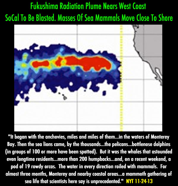
Subject: Re: Fukushima Radiation Plume Nears West Coast - Graphs & Vid 12-4-13
Fukushima Radiation Plume Nears West Coast - Graphs & Vid 12-4-13


 Email Article
  to increase the sampling size and enhance the representativeness of statistical results. [...] most pollutant particles move eastward and are carried by the Kuroshio and Kuroshio-extension currents and reach the east side of the North Pacific after about 3.2–3.9 years [...] the impact strength of nuclear pollutants at these time scales can be estimated according to the temporal variations of relative concentration combined with the radioactive decay rate. For example, Cesium-137, carried by the strong North Pacific current, mainly accumulates in the eastern North Pacific and its impact strength is 4% of the initial level at the originating Fukushima area after 4 years. [...]
