Guest
Guest
 |  Subject: LOOK OUT == IRMA WILL PROBABLY TURN AND DEVOUR EVERYTHING Subject: LOOK OUT == IRMA WILL PROBABLY TURN AND DEVOUR EVERYTHING  Thu Sep 07, 2017 8:41 am Thu Sep 07, 2017 8:41 am | |
| LOOK @ LAST COUPLE PICTURES And we all know that it is manipulated in direction by H and L's Seeding HAARPing and MicroWaving to the path of Destruction they wish it to travel TO WEAKEN AMERICA!!! https://www.wunderground.com/cat6/category-5-irma-hits-leeward-islands-peak-strength Category 5 Irma Hits Leeward Islands at Peak StrengthBob Henson · September 6, 2017, 12:40 PM EDT | | | Above: VIIRS infrared image of Hurricane Irma taken at 1:35 am EDT Wednesday, September 6, 2017. At the time, the island of Barbuda was in the eye, and Irma was a Category 5 storm with 185 mph winds. Image credit: UW-Madison/CIMSS. |
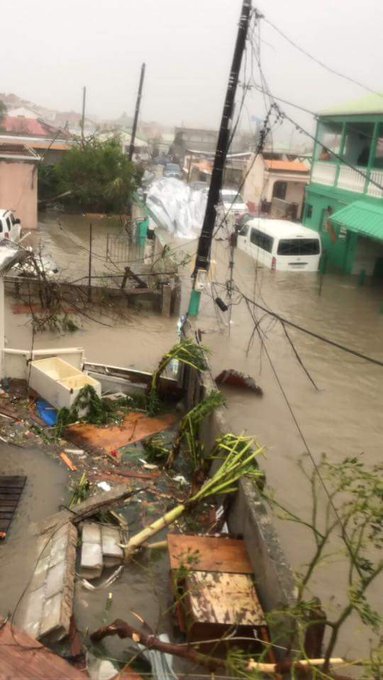
Hurricane Irma smashed into the small Lesser Antilles islands of Barbuda (population 1,638), Saint Barthelemy(population 9,000), Anguilla (population 15,000), and Saint Martin/Sint Maarten (population 8,000/33,000) early Wednesday as a mighty Category 5 hurricane with 185 mph winds. As the front southwestern eyewall of Irma hit, Barbuda reported sustained winds of 118 mph, gusting to 155 mph, before the instrument failed. The minimum pressure in the eye was 916 mb on Barbuda and St. Barthelemy. Preliminary reports from these islands indicate heavy wind and storm surge damage occurred. On Saint Martin, storm surge flooding to rooftop level was observed. Irma brought a storm surge of 7.95 feet (2.42 meters) to Barbuda, according to a Wednesday afternoon blog post by storm surge scientist Dr. Hal Needham. Barbuda has not been heard from yet.
A hurricane with top winds of 185 mph has never been recorded in these islands, and Irma’s landfall intensity of 185 mph winds in the Leeward islands is tied with the 1935 Florida Keys Labor Day Hurricane as the highest landfall intensity on record for an Atlantic hurricane (third place globally.) The most recent close analog for Irma may be Hurricane Hugo (1989), which tore through the Leewards and struck Puerto Rico as a Category 4 storm, causing $3 billion in damage (1989 dollars) and 72 deaths.
[ltr]
[/ltr] - Quote :
Follow
 Michel Spekkers @spekkers Michel Spekkers @spekkers
[ltr]Wat eerste foto's vanuit het Franse deel van St Maarten. Deel twee van #Irma is nu gaande (via Kevin Carty)[/ltr]
5:59 AM - Sep 6, 2017
1212 Replies
104104 Retweets
3838 likes
[size][size][ltr] Twitter Ads info and privacy [/ltr][/size] [/size]  | | Figure 1. Radar image of Irma taken at 1 am EDT September 6, 2017. The island of Barbuda is in the southwestern portion of the eye. A long loop of the radar (courtesy Brian McNoldy) shows the track of Irma over Barbuda and the Leeward Islands. Image credit: Meteo France. |
 | | Figure 2. Hurricane Irma as seen in moonlight by the VIIRS instrument on the Suomi satellite at approximately 3 am EDT Wednesday, September 6, 2017. Barbuda was in the southeastern eyewall of Irma at this time. Puerto Rico is visible at the left of the image. Image credit: NASA. |
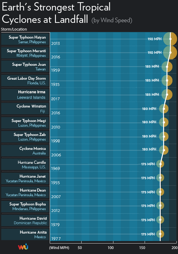 | | Figure 3. Irma’s landfall intensity of 185 mph winds in the Leeward islands is tied with the 1935 Florida Keys Labor Day Hurricane as the highest landfall intensity on record for an Atlantic hurricane, and is in third place globally. |
[size] Next targets: British Virgin Islands, U.S. Virgin Islands, and Puerto RicoOn Wednesday afternoon, Irma will make a direct hit on the British Virgin Islands, including Virgin Gorda (population 4,000), and Tortola (population 9,000.) The southern eyewall of Irma is also likely to affect the island of Saint John(population 4,000) in the U.S. Virgin Islands. A personal weather station on the south shore of St. Thomas measured sustained winds of 94 mph at 12:33 pm Wednesday. The island of Saint Thomas (population 52,000) may barely miss the eyewall of Irma, but northeastern portions of the island are still likely to receive sustained Category 1 hurricane winds of 75 – 90 mph. The same holds true for Puerto Rico’s Culebra Island. The extreme northeast corner of Puerto Rico should see slightly lower winds, near 60 – 80 mph.[/size]  | | Figure 4. Radar image of Irma from the Puerto Rico radar at 11:35 am EDT September 6, 2017. The northwest eyewall was over the British Virgin Islands. |
[size] Longer-range outlook for Irma: Cuba, the Bahamas, and Southeast U.S.Computer model guidance has begun to consolidate somewhat on Irma’s future during the period from Saturday onward, but there remains major uncertainty on exactly where Irma will track. Our top three track models—the European, GFS, and UKMET models—continue to agree strongly that Irma will continue on a west-northwest track through at least Friday. NHC predicts that Irma will still be a Category 5 hurricane through at least Friday morning. By late Thursday, Irma will likely be in or near the Southeast Bahamas, which are under a Hurricane Warning, with a Hurricane Watch for the Central Bahamas as of Wednesday morning. Some of the islands of the Southeast Bahamas may take a direct hit from Irma, and other islands may wind up in the dangerous right-hand side of the storm. Irma has the potential to be a devastating storm for The Bahamas, especially its southern islands, and residents should rush any needed preparations to completion.By Saturday, there is fairly strong model agreement that Irma will be located somewhere between the western Bahamas and Cuba, still on its west-northwest track. Irma will be paralleling the north coast of Cuba, and it is possible Irma’s center will move just inland along the coast for some period of time; parts of the north coast of Cuba are within the “cone of uncertainty” in the official NHC forecast. Residents of Cuba will need to pay very close attention to Irma’s track. The eastern two-thirds of Cuba was under a Hurricane Watch as of Wednesday morning. Irma is not expected to cross Cuba and move into the Caribbean.[/size]  | | Figure 5. Most likely arrival time of tropical-storm-force winds from Irma, as of the 11 am EDT Wednesday, September 6, 2017 advisory from NHC. |
[size] Models have been very consistent that Irma will take a sharp turn toward the north-northwest during the weekend, working its way around the west end of an upper-level ridge that has been steering Irma all week. The crucial question is exactly where and when Irma will take this right-hand turn, as that will play a huge role in possible impacts to the Southeast U.S. coast. Our top models shifted eastward on Tuesday night in their predictions of where the right-hand turn will occur, and the consensus is now that Irma is most likely to track from south to north either across the Florida Peninsula or just east of it, perhaps remaining near the coastline until moving further inland somewhere from Georgia to North Carolina. Irma is not expected to track sharply away from the Southeast U.S. coastline. A track along or just off the west coast of Florida is still possible. None of our reliable models bring Irma any further west than the Florida Panhandle, so the chance of Irma moving deeply into the central or western Gulf is increasingly remote. A track that curves north and stays just east of Florida is also possible; such a track could still bring Irma into the East Coast at a point further north early next week. Figures 6, 7 and 8 below show the range of possibilities in ensemble model guidance from Tuesday night (ensemble models include a number of parallel forecasts that reflect the uncertainty in a given weather situation).In short, computer guidance is in strong agreement that Irma will make at least one landfall somewhere from Florida to North Carolina during the weekend or early next week. The official NHC forecast track as of 11 am Wednesday brings Irma from near Miami to near Daytona Beach from Sunday morning to Monday morning. The 12Z Tuesday run of the GFS model predicts that Irma will hit Miami on Sunday afternoon, then make a second landfall near the Georgia/South Carolina border on Monday afternoon, with both landfalls occurring with at least Category 4 strength.The entire Florida peninsula and southeast Georgia are within the five-day cone of uncertainty in the official NHC forecast, and all residents of these areas should pay especially close attention to the progress of Irma. Residents of southeast Florida need to be especially vigilant.Intensity and storm surgeBy the time of its turn, Irma is still predicted to be a Category 4 hurricane by NHC, and the GFS and European forecast models imply that Irma could be close to Category 5 strength, especially if its center does not move onshore across northern Cuba. Wind shear is predicted to remain low to moderate along Irma’s path until Saturday, and Irma will be passing over waters that are as warm or slightly warmer than its current environment, so there is nothing that would be expected to cause major weakening of Irma other than potential land interactions, especially with Cuba. As Irma moves northward, increasing wind shear and interactions with land will likely begin to weaken Irma. However, Irma is expected to remain a major hurricane well after its northward turn, even if its center moves over the Florida peninsula and especially if the center remains just off the coast. The official NHC forecast as of 11 am Wednesday has Irma as a Category 3 storm on the east-central Florida coast on Monday morning.Because of Irma’s long life and its extreme strength, Irma will be pushing a tremendous amount of water through the Bahamas in the form of high waves and storm surge. Even if Irma’s winds weaken and its Saffir-Simpson category drops, Irma could still be capable of extreme storm surge, depending on its track and the geography of its landfall location(s). Storm surge expert Dr. Hal Needham noted in a blog post Wednesday: "The region from northeast Florida (St. Augustine) through all of the Georgia coast and southwest South Carolina is particularly vulnerable to storm surge, whether or not Irma makes a direct landfall in that region."[/size]  | | Figure 6. The 20 track forecasts for Irma from the 0Z Wednesday, September 6, 2017 GFS model ensemble forecast. Image credit: CFAN. |
 | | Figure 7. The 0Z September 6, 2017, track forecast by the operational European model for Irma (red line, adjusted by CFAN using a proprietary technique that accounts for storm movement since 0Z Wednesday), along with the track of the average of the 50 members of the European model ensemble (heavy black line), and the 50 track forecasts from the 0Z Wednesday European model ensemble forecast (grey lines). Image credit: CFAN. |
 | | Figure 8. The 0Z September 6, 2017, track forecast by the operational European model for Irma (red line, adjusted by CFAN using a proprietary technique that accounts for storm movement since 0Z Wednesday), along with the track of the average of the 50 members of the European model ensemble (heavy black line), and the track forecasts from the “high probability cluster” (grey lines)—the four European model ensemble members that have performed best with Irma thus far. All of these variations bring Irma very close to the Miami-Fort Lauderdale-Palm Beach corridor. Image credit: CFAN. |
 | | Figure 9. Infrared satellite image of Katia, Irma, and Jose as of 1530 (11:30 am EDT) Wednesday, September 6, 2017. Image credit: NASA/MSFC Earth Science Branch. |
[size] Meanwhile, we have Jose and KatiaTwo other tropical storms have developed since Tuesday morning. Tropical Storm Jose bolted to near-hurricane strength overnight, with top sustained winds of 70 mph as of 11 am Wednesday. Located about 1100 miles east of the Lesser Antilles, Jose is headed at 17 mph on a steady west-northwest track, steered by the same ridge that is helping to direct Irma. On its current track, Jose would reach the northern Leeward Islands by Saturday, but the ridge is predicted to weaken enough by Saturday to allow Jose to arc just northeast of the islands. Conditions are favorable for Jose to strengthen into a hurricane by later Wednesday, and it could approach Category 3 strength by late in the week. About 25% of the European model ensemble members bring Jose into the northern Leeward Islands, but all of the GFS ensemble members keep Jose north of the islands.Tropical Storm Katia was christened by NHC at 5 am EDT Wednesday, and its estimated top winds had increased to 45 mph as of 11 am EDT. Located in the Bay of Campeche about 175 miles north of Veracruz, Mexico, Katia is embedded in a very moist environment with numerous showers and thunderstorms along and south of a frontal zone (see Figure 9), and the storm’s core has become gradually more organized. NHC predicts that Katia will become a hurricane by Friday atop the bay’s very warm waters (30-31°C or 86-88°F). Wind shear will be dropping from about 10-15 knots to around 5-10 knots by Friday, which also supports development. Our top track models and the Euro and GFS ensembles are unanimous in drifting Katia for a couple of days before driving it southwestward into the Mexican coast this weekend. Extremely heavy rains of 10 – 20” are possible along parts of the northeast Mexican coast, especially in northern Veracruz, as Katia approaches and moves inland. Dr. Jeff Masters co-wrote this post.
[ltr]
[/ltr][/size] - Quote :
Follow
 NOAAHurricaneHunters NOAAHurricaneHunters
 @NOAA_HurrHunter @NOAA_HurrHunter
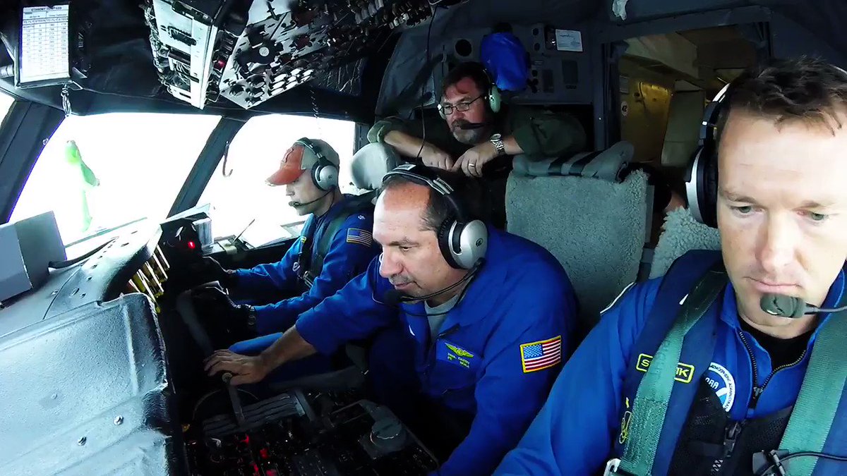
[ltr]Video from yesterday's flight in CAT 5 #Irma on #NOAA42. http://Hurricanes.gov has the latest advisories. Credit Rob Mitchell/NOAA[/ltr]
4:47 AM - Sep 6, 2017
234234 Replies
5,5815,581 Retweets
7,0287,028 likes
|
|


