Welcome to Watcher Forum
|
|
| | DONNELL FIRE UPDATE MAP, CLOSING IN ON ATV CAMP |  |
| | | Author | Message |
|---|
Guest
Guest
 |  Subject: DONNELL FIRE UPDATE MAP, CLOSING IN ON ATV CAMP Subject: DONNELL FIRE UPDATE MAP, CLOSING IN ON ATV CAMP  Fri Aug 10, 2018 2:07 pm Fri Aug 10, 2018 2:07 pm | |
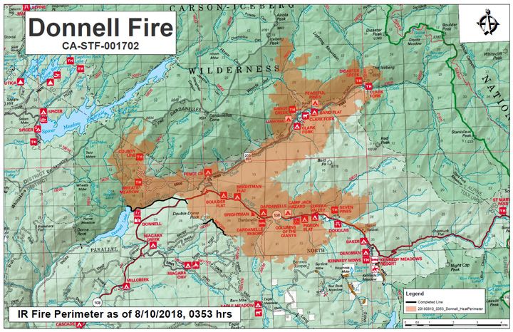
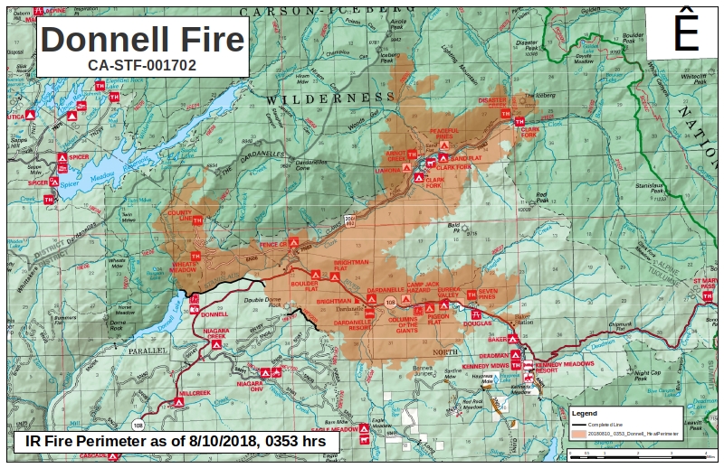
| https://www.mymotherlode.com/news/local/381655/new-growth-in-donnell-fire.html Update: Donnell Fire Continues To Grow In Stanislaus National Forest08/10/2018 12:05 pm PSTBJ Hansen, MML News DirectorUpdate at 10:05am: Last night crews battling the Donnell Fire continued structure protection along Highway 108 including backfiring operations east of Douglas tract and around Baker Station. A team also worked around the famous Bennett Juniper, building containment lines and added protection. High winds projected today create the potential for rapid fire growth. Yesterday air support dropped 42,000 gallons of retardant. Fix wing aircraft and helicopter support will continue today.While we reported earlier that Spicer reservoir is closed for recreational use, the campgrounds around it are open. The Pacific Crest Trail remains closed between Highway 108 and Highway 4.643 firefighters are now assigned to the incident. 220 structures are threatened. 55 major structures have been destroyed, along with 81 outbuildings. Also yesterday, Congressman Tom McClintock made a stop at base camp to hear an update on the fire fight. The latest size estimate remains 23,824 and there is 5-percent containment.Original story at 9am: Tuolumne County, CA — More areas are becoming off-limits due to the 23,824 acre Donnell Fire burning in the Stanislaus National Forest.This morning the US Forest Service issued an order closing the Carson-Iceberg Wilderness and Spicer Lake. The fire is considered 5-percent contained. We expect to have more information about the current strategies and the fire’s direction following the morning briefing at base camp.The mandatory evacuation orders remain in place for the Highway 108 corridor between Eagle Meadow and Kennedy Meadows. The advisory evacuation notice is still in place for the Mill Creek and Cascade Campgrounds. We’ll pass along more information as it becomes available.(SEE CLOSEST TO FIRE AT LOWER LEFT.. CAMP SITE WITH ATV, NIAGARA OHV, IS WHERE WE WERE AND IS A FAMILY FAVORITE) CLICK ON IMAGE AFTER FULL SIZE TEXT FOR SUPER SIZE Written by BJ Hansen.If you see breaking news, traffic or weather contact us at the News Hotline at 532-6397. If you have a photo regarding this news story or any Mother Lode News Story please email news@clarkebroadcasting.com.Fire information is located under the “Community” tab or keyword: fire
Last edited by spring2 on Fri Aug 10, 2018 2:32 pm; edited 3 times in total |
|   | | Guest
Guest
 |  Subject: Re: DONNELL FIRE UPDATE MAP, CLOSING IN ON ATV CAMP Subject: Re: DONNELL FIRE UPDATE MAP, CLOSING IN ON ATV CAMP  Fri Aug 10, 2018 2:25 pm Fri Aug 10, 2018 2:25 pm | |
| DESTROYING SOME BEAUTIFUL WILDERNESS AREAS.
VERY SAD!!!
I USED TO DO A LOT OF AMATEUR PHOTOGRAPHY, WISH I HAD MORE OF THIS AREA NOW!
WHEN RIDING I DO SOME OF THE TIME DO VIDEO. BUT UNFORTUNATELY NONE OF THIS AREA. |
|   | | Guest
Guest
 |  Subject: UPDATED MAP Subject: UPDATED MAP  Sat Aug 11, 2018 8:28 am Sat Aug 11, 2018 8:28 am | |
| Update at 8:20 pm.: The flames of the Donnell Fire in the Stanislaus National Forest crept closer toward Kennedy Meadows Friday, but it was a good day for aircraft battling the blaze, according to Incident Command.Both the acreage and conatinment held steady at 23,824 acres and 5% containment. Spokesperson Maria Benech reports there was not a lot of fire activity today, but pointed out, “We did have movement mainly on the eastside moving within two miles of Kennedy Meadows. So, it is creeping down Highway 108. There was also more activity in the northeast side in those canyons out of Clark Fork.”https://i.servimg.com/u/f83/19/80/67/56/2018_010.jpg  |
|   | | Guest
Guest
 |  Subject: SHORT INFO + NEW MAP! Subject: SHORT INFO + NEW MAP!  Sat Aug 11, 2018 5:25 pm Sat Aug 11, 2018 5:25 pm | |
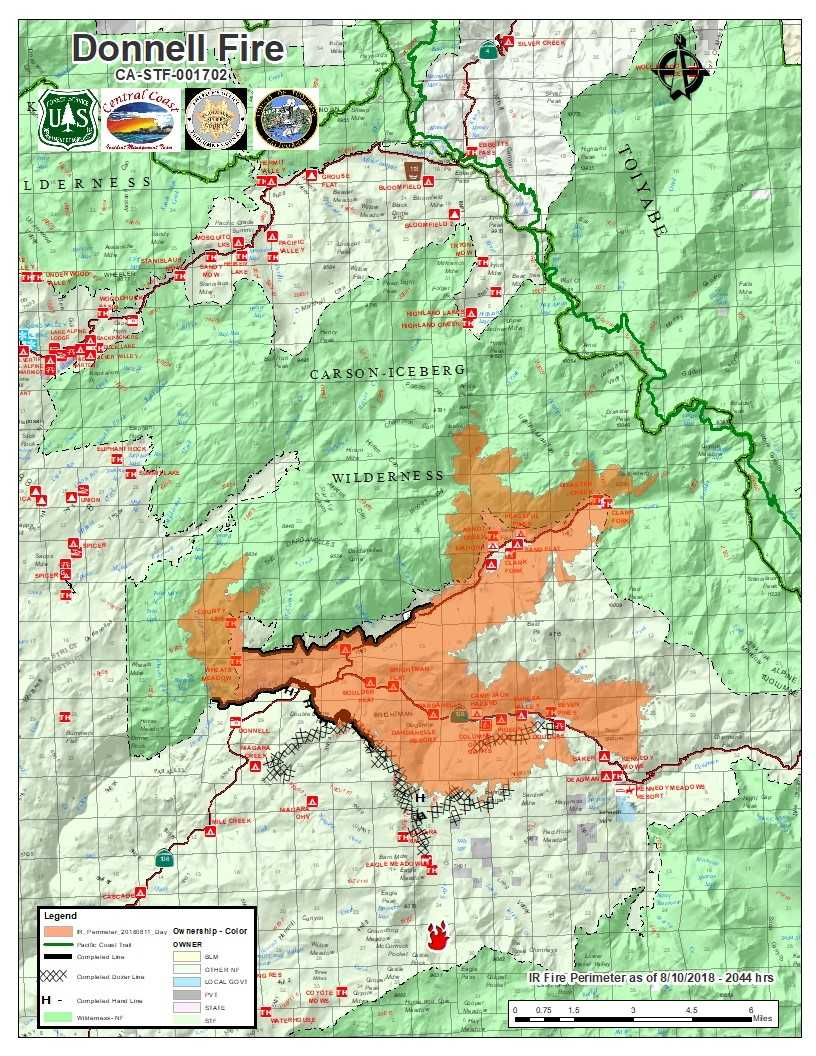
| https://www.mymotherlode.com/news/local/381892/donnell-fire-containment-hike-and-acreage-spike.htmlTuolumne County, CA — The Donnell fire has grown nearly 3,000 acres overnight to 26,814 acres but the containment also grew to 14 percent. Incident Command spokesperson Maria Benech shares, “We’re excited to have more crews on and very excited that the containment percentage is up to 14-percent. A lot of that is along north Clark Fork Road where they got that buttoned up. So that’s exciting to see for us.”Structural protection remains a priority for fire fighters along the Highway 108 corridor and 5N01/Eagle Meadow Road. Benech notes one area of concern, “The flames are about a mile or less from Kennedy Meadows.https://i.servimg.com/u/f83/19/80/67/56/donnel10.jpg

THERE IS NO NEWS ON THE JUNIPER BUT LOOKING AT THIS MAP IT APPEARS IT IS NOW SURROUNDED BY FIRE BURNING VERY LOW GRASS AND SMALL BUSHES, THE FIRE CREW THERE HAD ALREADY DONE SOME BACK BURNS AROUND SO I EXPECT IT TO BE OK? WE'LL SEE SOON. FIRE CREEPING VERY NEAR TO THE TWO LARGE CAMPGROUNDS THAT KENNEDY MEADOWS OPERATES ON THE WAY IN TO THE PACK STATION. THOSE ARE: BAKER AND DEAD MAN. THE FIRE CREW IS PRIMARILY PROTECTING THE PACK STATION STRUCTURES AND A VERY OLD CABIN... NO MENTION OF TRYING TO SAVE THE CAMPING AREAS. |
|   | | Guest
Guest
 |  Subject: Re: DONNELL FIRE UPDATE MAP, CLOSING IN ON ATV CAMP Subject: Re: DONNELL FIRE UPDATE MAP, CLOSING IN ON ATV CAMP  Sat Aug 11, 2018 5:37 pm Sat Aug 11, 2018 5:37 pm | |
| SORRY THE LAST MAP IS NOT AS GOOD AS QUALITY AS THE PREVIOUS AND DOES NOT SHOW THE SMALLER DIRT ROADS AS THE LAST NOR THE TREE LOCATION! IT'S QUALITY IS AS GIVEN. |
|   | | Guest
Guest
 |  Subject: Most Detailed Map Yet - Can Be Zoomed - All U.S. Subject: Most Detailed Map Yet - Can Be Zoomed - All U.S.  Sun Aug 12, 2018 8:14 am Sun Aug 12, 2018 8:14 am | |
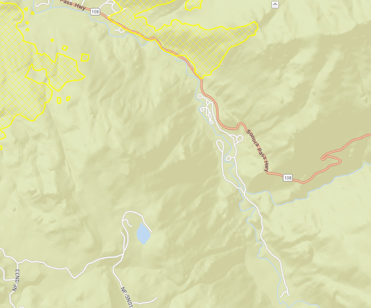
| https://www.geomac.gov/viewer/viewer.shtml 1. CLICK BUTTON ON LEFT LABELED "LAUNCH VIEWER". 2. ZOOM INTO STATE AND AREA. NOTE: CHECK BASE MAP UNDER DATA: SELECT USA TOPO AS YOU ZOOM IN THE YELLOW AREAS ARE FIRE BORDERS, NAMES WILL BECOME VISIBLE, CAMPGROUNDS AND OTHER POINTS OF INTEREST AS WELL AS WHAT THE TERRAIN LOOKS LIKE. ZOOMING IN ON REGULAR STREET CAN ALSO GIVE DIRECTION ADDRESSES RUN! BOOKMARK, IT CAN BE HANDY WITH NO GPS OR CELL NEAR BY. PICTURE FROM 10 AUG (UNFORTUNATELY NOT TOO UP TO DATE) DOES SHOW CLOSER VIEW THOUGH.  https://inciweb.nwcg.gov/incident/6092/ IS SIMILAR WITH BETTER TOPOGRAPHICAL ELEVATION LEVELS, JUST CHECK THE DATES!!!! https://www.fs.fed.us/science-technology/fire/information ALSO |
|   | | Guest
Guest
 | |   | | Sponsored content
 |  Subject: Re: DONNELL FIRE UPDATE MAP, CLOSING IN ON ATV CAMP Subject: Re: DONNELL FIRE UPDATE MAP, CLOSING IN ON ATV CAMP  | |
| |
|   | | | | DONNELL FIRE UPDATE MAP, CLOSING IN ON ATV CAMP |  |
|
Similar topics |  |
|
| | Permissions in this forum: | You cannot reply to topics in this forum
| |
| |
| |
|


