https://halturnerradioshow.com/index.php/en/news-page/news-nation/large-explosion-at-cape-cod-icbm-early-warning-radar-station
Large Explosion at Cape Cod ICBM Early Warning RADAR Station!
There has been a large explosion near the Cape Cod Air Force Station's PAVE PAWS (ICBM Early Warning) Radar Station, near Sagamore, Massachusetts, USA (Cape Cod). A large fire is presently burning there.
PAVE PAWS stands for Precision Acquisition Vehicle Entry Phased Array Warning System.
The explosion was so large that workers over two miles away heard it. One worker reports "When I looked outside, the sky was filled with gray and orange smoke, just like that explosion which destroyed the port of Beirut, Lebanon" he said.
Cape Cod Air Force Station is the
only land based radar site providing missile warning
for the eastern coast of the United States and southern Canada against intercontinental and sea-launched ballistic missiles.
Perched high atop Flatrock Hill near the quiet Massachusetts town of Sandwich, MA stands a PAVE PAWS radar station.
The pyramid-shaped facility rests on the 100-acre Cape Cod AFS and is
home to Air Force Space Command's 6th Missile Warning Squadron.
The radar looms 10 stories high against the backdrop of New England's rolling hills. The mission of the approximately 200 people who man the radar, is to date and
track sea-launched ballistic missiles heading for North America.They also use the radar to track satellites in orbit, transmitting spacetrack data into the Space Surveillance Center at Cheyenne Mountain.
At the operational heart of the Cape Cod facility is the Missile Warning Operations Center where AFSPACECOM and Canadian crews monitor consoles around-the-clock which display tracking data. Crews consisting of a crew commander, crew chief and a space console operator use the data to warn of potential attacks on North America.
If the continental United States were to be attacked, taking-out THIS PRECISE RADAR STATION would be a necessary first step for any adversary.
The photo at the top of this article shows the situation at the radar station a few hours ago.
Below is a scalable map for you to see the actual location and surrounding area:
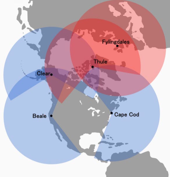
The United States has very few of these PAVE PAWS Radar systems because the areas they cover are so enormous. The graphic below shows the US PAVE PAWS Early Warning Radar System. From that, you can see how vital the Cape Cod system is:

It should be pointed out that, using the Google scalable map above, there is no structure or facility large enough to burn like that, within at least a MILE of the radar array, which itself is ten stories tall.
It is beginning to appear that PERHAPS (just a guess) this was an effort by an adversary to take out our early warning radar . . . and they missed. If that guess is correct, we may have just avoided a first-strike by an adversary who plans to take us out.
If so, they may try again. Soon.


