THEY HAVE NO RIGHTS!!!https://www.mymotherlode.com/news/local/382111/resources-heading-to-reported-fire-near-crystal-falls.html
Update: Resources Heading To Reported Fire Near Crystal Falls Crystal Falls area house fire road closure Aug 13 2018
 Enlarge
Meanwhile, the Tuolumne County Sheriff’s Office has a temporary road closure in place at Smokey River Drive and Longeway Road as well as at Red River Drive.
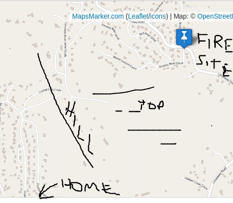
Sheriff’s officials commend the firefighters’ quick and efficient response.Update at 1:05pm: CAL Fire officials report that a residential fire that broke out in the Crystal Falls area has been contained in the building where it reportedly began.CAL Fire spokesperson Emily Kilgore adds that units are still actively working the incident, which is in the vicinity of Smokey River Drive and Longeway Road. You will want to avoid the area at this time if at all possible due to firefighting activity and other responding units.Original Post at 12:55pm: Sonora, CA — Air and ground resources are responding to a report of a fire in the vicinity of Smokey River and Longeway roads in the Crystal Falls area. (my area)CAL Fire officials say as units are still arriving it is unknown whether reports of smoke are coming from vegetation or the back of a building. We will bring you more details as they come into the news center.map:

wind direction toward me

SEE LINK FOR MAP I LIVE BELOW THISNOT GIVING DETAILS, SECURITY REASONS.THIS DID WORRY ME BECAUSE OF WIND DIRECTION AND THE FACT MY ONLY TRUCK AVAILABLE IS BEING WORKED ON AND CANNOT BE USED FOR A WEEK!
FIRE THAT CLOSE COULD BECOME VERY DANGEROUS AS I HAVE JACK THE GRANDSON WITH ME... GUESS A ATV AND TRAILER COULD BECOME NECESSARY!
LITTLE ON EDGE WITH STUFF GOING ON...
THE SCANNER WAS NOT IN THE HOUSE AND I WAITED A FEW MINUTES TOO LONG TO GET THE ADDRESS... THERE WERE ALL SORTS OF RADIO STUFF GOING ON WITH NO VOICE TRANSMISSIONS... I AM ABLE TO SEE WHO BUT WHEN NO VOICE YOU GOTTA WONDER WHAT IS GOIN ON"
DID HEAR A MEDIVAC IN COLUMBIA AIRPORT NEAR BY BUT NOT ENOUGH DETAILS..
SO THERE YOU HAVE IT, IT WAS CLOSE... LOOK AT THE MAP FOR CRYSTAL FALLS DR.
I LIVE A BLOCK FROM THAT NEAR THE BOTTOM OF THE HILL WHERE THE FIRE WAS.
OUT THE DOOR TO GET THE SCANNER I NOTED THE WIND DIRECTION AND KNEW IT WAS NOT GOOD!!!!
STAY SAFE
PAY ATTENTION TO THE ELEMENTS AROUND YOU!!!
HELPS.
DAVE


