!!! IMPORTANT !!! = Destruction Coming to the US West Coast: USGS Hiding Key Seismic Data-TERRAL
Author
Message
Guest Guest
Subject: !!! IMPORTANT !!! = Destruction Coming to the US West Coast: USGS Hiding Key Seismic Data-TERRAL Tue Jul 23, 2019 9:59 pm
PAY VERY CLOSE ATTENTION TO THIS AS IT WILL AFFECT OTHER STATES AS WELL!!
Destruction Coming to the US West Coast: USGS Hiding Key Seismic Data July 23 2019
https://youtu.be/eqhKsFDxfYY
DUTCHSINSE AND TERRAL ARE THE ONES TO WATCH!!!!! THEY ARE THE ONES!!!
Terral BlackStar Published on Jul 23, 2019
[size=18]SUBSCRIBE 18K[/size]
Please Subscribe, Like, Ring the Bell (for Updates) and share this Special Report video link with others.
Subscribe to the Newsletter-Survival Group Programs, support the research and get more information at https://www.terral03.com.
Contact Terral: terral@terral03.com.
The USGS is systematically hiding key seismic data from US Citizens and the world to head off panic concerning the destruction of the US West Coast that is already underway and happening in slow motion before our eyes. Rosanne sent this warning video: https://youtu.be/CBOyfDVUGCw Bonnie’s Dutchsinse video: https://www.youtube.com/watch?v=7Cq2C... Rosanne’s video is an American Underground Army Red Alert! Warning message about what is coming to the US West Coast that everyone in the region is wise to heed before the crap hits the fan. Bonnie’s video includes a lot of information on how the USGS is systematically hiding and changing seismic data, so that researchers are thrown off the track in connecting the dots for drawing the right conclusions that destruction and devastation are coming to the region. https://cloverchronicle.com/2019/07/0... This article warns of a new supervolcano forming under China Lake, when in reality magma displacement is taking place throughout the region with many earthquake events striking below the 20-kilometer depth. Everyone with the resources has been warned repeatedly to relocate away from regions west of the Rocky Mountain Ridge and east of the Mississippi River Basin onto the North American Craton where Terral03.com currently has four survival group programs with three in the Ozarks and one along the Texas-New Mexico border. Below we find examples of USBS trickery where smaller-shallower quake data is systematically replacing the original information. Earthquakes are striking below the 20-kilometer depth all the way from the Seattle area of Washington State south into Mexico and everywhere in between and in patterns pointing to destruction coming to the entire region later in the timeline. Deep Quakes Continue Striking under US West Coast https://earthquake.usgs.gov/earthquak... M 2.7 - 36km NNE of Trona, CA • 2019-07-06 22:54:58 (UTC) • 36.036°N 117.163°W • 26.3 km depth !!! USGS changed to this: M 2.4 - 22km ESE of Little Lake, CA • 2019-07-06 22:55:05 (UTC) • 35.854°N 117.685°W • 9.5 km depth https://earthquake.usgs.gov/earthquak... M 2.5 - 18km NNE of Fort Irwin, CA • 2019-07-09 01:42:56 (UTC) • 35.420°N 116.623°W • 28.6 km depth !!! USGS changed to this: M 1.5 - 25km NW of Searles Valley, CA • 2019-07-09 01:43:12 (UTC) • 35.918°N 117.608°W • 2.9 km depth https://earthquake.usgs.gov/earthquak... M 2.6 - 9km W of Wofford Heights, CA • 2019-07-09 10:27:09 (UTC) • 35.715°N 118.558°W • 20.7 km depth USGS changed to this: M 1.0 - 8km E of Coso Junction, CA • 2019-07-09 10:27:20 (UTC) • 36.035°N 117.859°W • 1.9 km depth This week: https://earthquake.usgs.gov/earthquak... M 2.5 - 16km NNW of Searles Valley, CA • 2019-07-10 09:20:05 (UTC) • 35.884°N 117.500°W • 25.1 km depth USGS changed the data to: M 1.3 - 17km NE of Little Lake, CA • 2019-07-10 09:20:10 (UTC) • 36.031°N 117.756°W • 4.5 km depth
This Special Report video and written article are posted in Terral's 2019 Newsletter Volume 30 published this Thursday afternoon for valued Newsletter-Survival Group Subscribers and Supporters of the research at https://www.terral03.com.
Last edited by spring2 on Wed Jul 24, 2019 10:59 am; edited 2 times in total
Guest Guest
Subject: Re: !!! IMPORTANT !!! = Destruction Coming to the US West Coast: USGS Hiding Key Seismic Data-TERRAL Tue Jul 23, 2019 11:06 pm
THE DATA IS BEING CHANGED AND TERRAL CITES DUTCH'S WORK!!!
DUTCH IF YOU SEE THIS, GET TOGETHER WITH TERRAL .. UNDERSTANDING WILL HELP!!
Guest Guest
Subject: Re: !!! IMPORTANT !!! = Destruction Coming to the US West Coast: USGS Hiding Key Seismic Data-TERRAL Tue Jul 23, 2019 11:08 pm
TERRAL NEEDS MORE CRUSTAL THICKNESS MAPS !!!!
Guest Guest
Subject: Re: !!! IMPORTANT !!! = Destruction Coming to the US West Coast: USGS Hiding Key Seismic Data-TERRAL Tue Jul 23, 2019 11:11 pm
LISTEN LISTEN MORE FOR YOU BESIDES EQ NEWS!!!! NANO BORAXO APPLE CIDER VINEGAR
Guest Guest
Subject: CAN'T SEE THE PRESSURE BUILDING AS TERRAL03 IS POINTING OUT?? Wed Jul 24, 2019 8:29 am
https://strangesounds.org
CAN'T SEE THE PRESSURE BUILDING AS TERRAL03 IS POINTING OUT?? HERE: look at their headlines.. believe them??
Guest Guest
Subject: CAN'T SEE THE PRESSURE BUILDING AS TERRAL03 IS POINTING OUT?? Wed Jul 24, 2019 8:31 am
https://strangesounds.org
CAN'T SEE THE PRESSURE BUILDING AS TERRAL03 IS POINTING OUT?? HERE: look at their headlines.. believe them??
Guest Guest
Subject: Giant cracks in the ground appear in Mojave Desert near the epicenters of California latest two major earthquakes Wed Jul 24, 2019 8:54 am
Giant cracks in the ground appear in Mojave Desert near the epicenters of California latest two major earthquakes
By Strange Sounds - Jul 7, 2019
[size=27]There were multiple fissures that broke the ground in the Mojave Desert in southern California on Thursday and Friday after two major M6.4 and M7.1 earthquakes struck the area.
The power of nature is amazing… And these deep fissures near Ridgecrest, California are just terrifying!
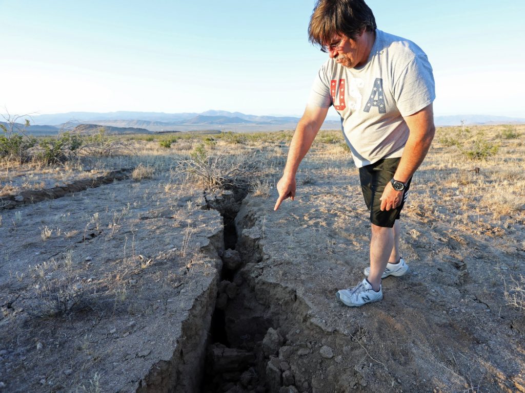
A deep fissure discovered in the Mojave Desert near Ridgecrest, the epicenter of the M6.4 earthquake in Southern California on July 4, 2019. Picture by David McNew/Reuters On the Fourth of July, people from Los Angeles to Las Vegas felt the ground shake. Books fell off library shelves, trees collapsed, and cracks spidered through building walls and highway asphalt.
[/size]
Quote :
Gary Warner@BendStateBureau
[ltr]Fissure near Ridgecrest, Calif., after 6.4 scale quake this week. USGS says a 9.1 scale Cascadia quake in Oregon would release 11,200 times more energy. Photo by Mario Tama/Getty Images . #orleg #orpol https://earthquake.usgs.gov/learn/topics/calculator.php …[/ltr]
6 5:50 PM - Jul 5, 2019 Twitter Ads info and privacy
[size][size][ltr]
See Gary Warner's other Tweets
[/ltr]
The magnitude 6.4 earthquake was centered in the California city of Ridgecrest, about 175 miles northeast of Long Beach. It ended a five-year drought in California’s seismic record: Before yesterday, the ground had not shook in the state since a magnitude 6 quake struck Napa in August 2014, causing $1 billion in damages.
video: may need to see link
Then, a 7.1 magnitude quake centered about 11 miles north of Ridgecrest struck at 8:19 p.m. Friday, rattling the Kern County city of 27,000 and the nearby small town of Trona in San Bernardino County.
[/size][/size]
Quote :
KTLA
:heavy_check_mark:@KTLA
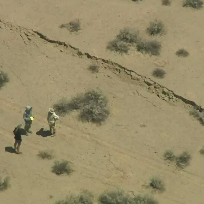
[ltr]Check out this fissure near the site of last night's magnitude 7.1 earthquake outside Ridgecrest. Sky5 was overhead late this morning. Full coverage at http://ktla.com [/ltr]
2,933 1:27 PM - Jul 6, 2019 Twitter Ads info and privacy
[size][size][ltr]
1,702 people are talking about this
[/ltr]
The area appears to have taken the brunt of the damage, which includes major cracking on the State Route 178, at least one collapsed building and a fissure that stretched across the Mojave Desert.
[/size][/size]
Quote :
CBS Los Angeles
:heavy_check_mark:@CBSLA
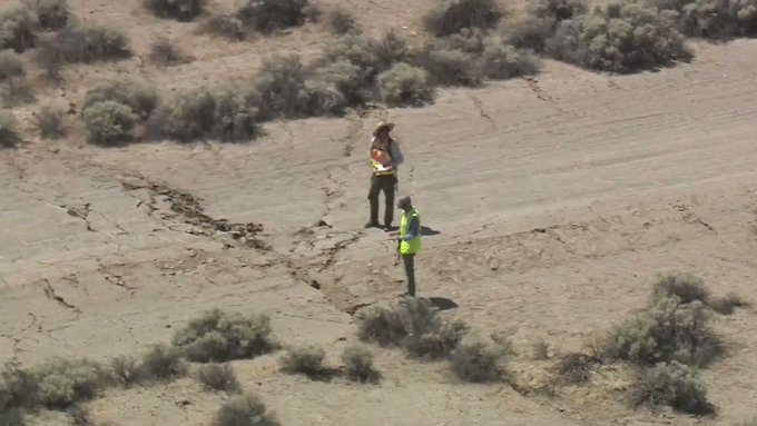
[ltr]GROUNDBREAKING: SKY2 captured a large earth fissure that formed after Friday's 7.1-magnitude earthquake near Ridgecrest https://cbsloc.al/2NFfpI4 [/ltr]
591 2:40 PM - Jul 6, 2019 Twitter Ads info and privacy
[size][size][ltr]
333 people are talking about this
[/ltr]
Both major earthquakes have created large and very impressive cracks in the ground of the dry Mojave Desert. The power of nature is somehow very creepy! [Twitter, Global News, KTLA][/size][/size]
Sponsored content
Subject: Re: !!! IMPORTANT !!! = Destruction Coming to the US West Coast: USGS Hiding Key Seismic Data-TERRAL
!!! IMPORTANT !!! = Destruction Coming to the US West Coast: USGS Hiding Key Seismic Data-TERRAL