Guest
Guest
 |  Subject: America’s Destiny Revealed within Her Landscape, Part II: Her Heart Of Stone Subject: America’s Destiny Revealed within Her Landscape, Part II: Her Heart Of Stone  Mon Nov 04, 2013 10:20 am Mon Nov 04, 2013 10:20 am | |
| America’s Destiny Revealed within Her Landscape, Part II: Her Heart Of StonePosted on October 5, 2013by CARLOS MONTAÑA————————————————————————————————————A Personal Note-As I pen this paragraph it is 28 September, 2013. I have just gotten back to writing after many months away from any work on this most pertinent and now time-sensitive article. Moments ago I was pacing the room and procrastinating about “other things to do” in place of writing when I noticed a scrap of paper on the floor. As I always strive to keep my work area organized, I picked it up, turned it over, and read this-START!!!Obviously this was a book marker which had apparently just fallen out of one of countless books on the shelf above. I took this, however, as a sign from God and immediately started back on the writing! It is about time I finish this article as it’s been five years since the discovery . . . five years of grace?Background & Introduction-Back in early autumn of 2008, shortly after I had come to the shocking realization that America is Babylon the Great of Bible renown, the Lord led me to a large wall map of the United States of America and brought back to me a vivid memory of a particular childhood trip out West to the heartland of America. Through the Holy Spirit, then, He showed me something astounding about this particular place and finally, after five years of delay, I will share the results of this revelation with the world. This may well represent the most important research I have ever undertaken and published.Since that fall day in 2008 I have traveled the Midwest and West of this beautiful country in order to pursue additional clues and documentation which I will present herein. Hopefully, you will find the fruits of this revelation to be shocking, and clearly well beyond mere “coincidence”. Furthermore, if you had any doubt that America is Babylon the Great prior to reading this article, such doubts should be erased. Most importantly, however, this article is intended to reach those patriotic American Christians who just cannot accept the truth that their dear nation could possibly be Babylon of the end times, despite the abundant proof offered in Isaiah, Jeremiah, and Revelation, as well as through the words of other Bible Prophets. With this article, assuming that I have done my job properly in presenting these findings, it is my prayerful hope that the Holy Spirit will be opening the spiritual eyes of scores of American citizens. That is to say that these results can only act to make “visible” to some people what has been obscured to them in the past due to their own spiritual blindness or simply an (understandable) inability to accept the very, very difficult Biblical truth that America is prophetic Babylon, and that her judgment is nigh. I can relate, for as a current “reformed American patriot” I used to be one of those people.But right now, let me state very strongly as I do not want there to be any misunderstanding- the identity of America as Babylon the Great is found within Scripture and Scripture alone. All necessary evidence to this effect can be discovered within the inspired pages of the Holy Bible. May this article, if it opens your eyes, lead you into the Bible and may you study the numerous Babylon prophecies contained therein with renewed interest and fervor. Now, without further ado, let me just remind you all that this is the second installment in my America’s Destiny Revealed within Her Landscape series; the first is found here-http://nabiy4america.wordpress.com/2011/05/12/america%e2%80%99s-destiny-foretold-within-her-landscape-part-i-mississippi-river-2013-code/And, yes, it would be minimally helpful to familiarize yourself with the methods of Part I before diving into this Part II although the two articles are certainly written that they might stand independent of one another. Within Part I there is much discussion of the Mississippi River “geographic center” as calculated by two different methods, as well as the population center of the USA. I shall be revisiting these methods within this article, with primary focus not on the Mississippi River and population but rather on the precise geographic centers of both the conterminous forty-eight (48) states and of the entire nation (50 states). In addition I will be discussing the history and spiritual implications of America’s first National Monument. Finally, I will also examine the addition of Alaska and Hawaii into the Union and suggest potential spiritual effects of these historic events in the year 1959.Geographic Centers/Centroids: Meaning & Methods of Calculation-How is the “center” of any irregularly-shaped landmass defined? First, we must think in terms of the following two designations, which I’ll use quite interchangeably throughout the article. These are “geographic center” and “centroid”. But what does this mean, in layman’s terms? A geographic center, or centroid, of a place is basically the point at which the shape “balances”, the “middle” of any shape; the center of gravity or mass, if you will. You have to imagine the shape as flat and of equal thickness throughout- the center, then, is the point of balance, and is generally near the place “our eyes want to go” when we view the shape. If I were to cut out a cardboard map of the state of Texas, it would be the point at which I could balance the map on a thin vertical rod, pencil, or fingertip. For Texas, this point/center is, by the way, near the town of Brady, in McColloch County. This method is generally used as a “test confirmation” after completing the “plumb line method” of weighted strings, an ancient and well established technique. Although seemingly rather “crude”, both methods are shockingly accurate and complimentary, and are shown here (see, especially, the 2nd figure in the article below)-http://dev.physicslab.org/Document.aspx?doctype=3&filename=RotaryMotion_CenterMass.xmlAnd here-http://www.scn.org/~bh162/center_of_mass.pdfA final way to accomplish this objective is through a calculus-based program with extremely rigorous modeling required (as well as various “assumptions” especially in working with coastal regions). In this report I will rely on published models such as those of both the US Government and Richeson (2004), but will make mathematical corrections for oversights and shortcuts within those models; this said, the calculus-based Richeson model is generally preferable to that of the Government.For example, take a look at the map below of the conterminous United States and try to discern where the center might be; likely your eyes will be drawn to the general region of northern Kansas (KS) or perhaps southernmost Nebraska (NE); this is “close” as I will demonstrate-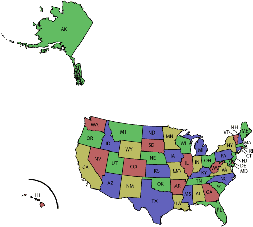 First, though, I must admit as any scientist must, that the calculation of geographic centers represents an inexact science. However, you will see that I have taken great pains to prove my thesis, and that the results are therefore convincing.I will next discuss the geographic center of the conterminous 48 states, and much later in this article I’ll demonstrate how the addition of Alaska and Hawaii as the final two states acts to “shift” this center several hundred miles in a northwesterly direction.The Geographic Center of the Conterminous 48 states of America-In the years prior to the inclusion of Alaska and Hawaii to the United States of America, which occurred in 1959, several calculations or estimates were published which represented attempts to mathematically or otherwise determine the precise “geographic center” or “centroid” of the 48 conterminous states.Utilizing the “center of gravity” method, the official US Government-sanctioned centroid is established at just north of Lebanon, Kansas, with a separate centroid, situated by an international Transcendental Meditation (TM) group, being approximated at Smith Center, Kansas. Interestingly, this TM group has purchased 480 acres just south of Smith Center to develop that which they call the Brahmasthan (spiritual center) of America and specifically are claiming this plot of land to represent the World Capital of Peacemeant “to raise America to invincibility and to promote peace globally“! Here is what the leader of the group, His Holiness Maharishi Mahesh Yogi, has prophesied (falsely, I might suggest)- First, though, I must admit as any scientist must, that the calculation of geographic centers represents an inexact science. However, you will see that I have taken great pains to prove my thesis, and that the results are therefore convincing.I will next discuss the geographic center of the conterminous 48 states, and much later in this article I’ll demonstrate how the addition of Alaska and Hawaii as the final two states acts to “shift” this center several hundred miles in a northwesterly direction.The Geographic Center of the Conterminous 48 states of America-In the years prior to the inclusion of Alaska and Hawaii to the United States of America, which occurred in 1959, several calculations or estimates were published which represented attempts to mathematically or otherwise determine the precise “geographic center” or “centroid” of the 48 conterminous states.Utilizing the “center of gravity” method, the official US Government-sanctioned centroid is established at just north of Lebanon, Kansas, with a separate centroid, situated by an international Transcendental Meditation (TM) group, being approximated at Smith Center, Kansas. Interestingly, this TM group has purchased 480 acres just south of Smith Center to develop that which they call the Brahmasthan (spiritual center) of America and specifically are claiming this plot of land to represent the World Capital of Peacemeant “to raise America to invincibility and to promote peace globally“! Here is what the leader of the group, His Holiness Maharishi Mahesh Yogi, has prophesied (falsely, I might suggest)- - Quote :
- The problems of America will disappear, as darkness disappears with the onset of light.
This is not a joke; you can read the article here-http://istpp.org/news/2006_04_brahmasthan.htmlAnd courtesy of the Denver Post, we have the reaction of local residents to these naive and fruitless plans-http://www.denverpost.com/ci_4174504?source=rssI passed by this place in June of 2011, and the most startling image from the road is what is called Liberty of the Plains-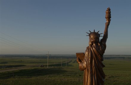 Basically, this is an attempt to establish a Babylonian-inspired religious place of worship at the very center of America. However, this “center of the nation” or centroid location at Smith Center has been debunked already in light of more accurate calculations; other debunked centroids include Glenvil, Nebraska; Glenola, Kansas; and the vicinity of Camp Funston (Fort Riley), Kansas. Incidentally, Camp Funston was the incubation point of the 1918 Spanish Flu which killed tens of millions of people worldwide. The actual starting point was a hog farm in the southwestern part of . . . you guessed it . . . the state of Kansas.The official Government centroid I mentioned earlier, just north of Lebanon, Kansas, is a lovely little spot marked by both a small white chapel and a sandstone pyramid, or ziggurat. As you read further, you should see that the choice of a pyramid to represent America’s precise center has rather stunning implications for the nation. And, interestingly, although it is built of “rock” it is also built of “sand” (Matthew 7:24-26).Also I must mention that when I visited this site in June of 2011 my tour guide pointed up the hill to a non-descript spot of land a couple of hundred feet away and claimed that was the actual exact center; it was in the middle of a hog farm!Here is the official Government geographic center as marked on a map of Lebanon-http://www.ksdot.org/burtransplan/maps/city-pdf/lebanon.pdfAnd please see this nice article for a quick review of the official site-http://www.kansastravel.org/geographicalcenter.htmFinally, here are the pictures mentioned- Basically, this is an attempt to establish a Babylonian-inspired religious place of worship at the very center of America. However, this “center of the nation” or centroid location at Smith Center has been debunked already in light of more accurate calculations; other debunked centroids include Glenvil, Nebraska; Glenola, Kansas; and the vicinity of Camp Funston (Fort Riley), Kansas. Incidentally, Camp Funston was the incubation point of the 1918 Spanish Flu which killed tens of millions of people worldwide. The actual starting point was a hog farm in the southwestern part of . . . you guessed it . . . the state of Kansas.The official Government centroid I mentioned earlier, just north of Lebanon, Kansas, is a lovely little spot marked by both a small white chapel and a sandstone pyramid, or ziggurat. As you read further, you should see that the choice of a pyramid to represent America’s precise center has rather stunning implications for the nation. And, interestingly, although it is built of “rock” it is also built of “sand” (Matthew 7:24-26).Also I must mention that when I visited this site in June of 2011 my tour guide pointed up the hill to a non-descript spot of land a couple of hundred feet away and claimed that was the actual exact center; it was in the middle of a hog farm!Here is the official Government geographic center as marked on a map of Lebanon-http://www.ksdot.org/burtransplan/maps/city-pdf/lebanon.pdfAnd please see this nice article for a quick review of the official site-http://www.kansastravel.org/geographicalcenter.htmFinally, here are the pictures mentioned- 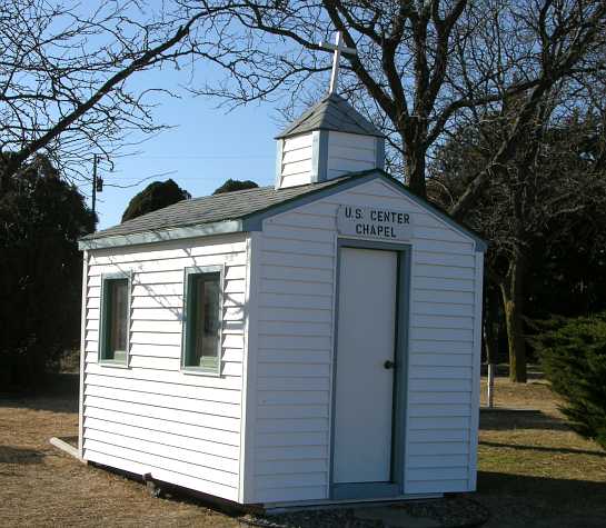 During my visit I walked into the small chapel to pray. There, I noticed a Bible upon thelectern. It was open to Ezekiel 38, as such- During my visit I walked into the small chapel to pray. There, I noticed a Bible upon thelectern. It was open to Ezekiel 38, as such-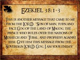 Back outside, I walked over to check out the pyramid structure and found out that it was dedicated by a group called “The Lebanon Hub Club”; in my research I was unable to find out if this group night have been Masonic in character which would “fit” with my theory of why they would choose the symbol of a pyramid to be topped, on occasion, with a huge American flag. The site itself, especially a small motel which used to be on location but has long since closed, has seen a bit of fleeting fame due to an award-winning 2001 book entitled American Gods written by Neil Gaiman. In this fictional work, the author discusses the plethora of spirits from various parts of the world which have all taken up residence in America, in addition to indigenous spirits “created” by the desires of the people. Although certainly not written from the Biblical worldview, I must say that there is much spiritual truth in this work of fiction. Americans as a whole surely worship a multitude of false gods.According to published reports the US Government arrived at the Lebanon centroid using the “plumb line center of gravity” approach. They also give an error factor of 20 miles in any direction, and the Chief Mathematician himself at the time, Mr. O.S. Adams, basically called such a calculation “a waste of time and resources.” With all due respect to the “official” nature of the Government centroid north of Lebanon, I bet to differ as there is another calculated centroid which is significantly more accurate. You see, contrarily, Richeson (2004) took his challenge seriously and has used calculus in an attempt to prove that the true center of the conterminous 48 states is actually 40 miles to the West of the Lebanon location, in Phillipsburg, Kansas. I believe that this is close; in fact, very close (I’ll address this issue shortly). Apparently the city of Phillipsburg, Kansas does not have any official site marked as to the geographic centroid. Perhaps city leaders are not even aware of this rather recent article by Richeson? Anyway, here’s a quick look at Phillipsburg-http://www.phillipsburgks.us/An “All-American” town, for sure. Using data derived from Richeson (2004) I calculatedhis precise center to be at the southwestern city limits of Phillipsburg and took this picture during my research travels in June 2011 to document what I discovered in the vicinity of this spot (“click pic” for larger view)- Back outside, I walked over to check out the pyramid structure and found out that it was dedicated by a group called “The Lebanon Hub Club”; in my research I was unable to find out if this group night have been Masonic in character which would “fit” with my theory of why they would choose the symbol of a pyramid to be topped, on occasion, with a huge American flag. The site itself, especially a small motel which used to be on location but has long since closed, has seen a bit of fleeting fame due to an award-winning 2001 book entitled American Gods written by Neil Gaiman. In this fictional work, the author discusses the plethora of spirits from various parts of the world which have all taken up residence in America, in addition to indigenous spirits “created” by the desires of the people. Although certainly not written from the Biblical worldview, I must say that there is much spiritual truth in this work of fiction. Americans as a whole surely worship a multitude of false gods.According to published reports the US Government arrived at the Lebanon centroid using the “plumb line center of gravity” approach. They also give an error factor of 20 miles in any direction, and the Chief Mathematician himself at the time, Mr. O.S. Adams, basically called such a calculation “a waste of time and resources.” With all due respect to the “official” nature of the Government centroid north of Lebanon, I bet to differ as there is another calculated centroid which is significantly more accurate. You see, contrarily, Richeson (2004) took his challenge seriously and has used calculus in an attempt to prove that the true center of the conterminous 48 states is actually 40 miles to the West of the Lebanon location, in Phillipsburg, Kansas. I believe that this is close; in fact, very close (I’ll address this issue shortly). Apparently the city of Phillipsburg, Kansas does not have any official site marked as to the geographic centroid. Perhaps city leaders are not even aware of this rather recent article by Richeson? Anyway, here’s a quick look at Phillipsburg-http://www.phillipsburgks.us/An “All-American” town, for sure. Using data derived from Richeson (2004) I calculatedhis precise center to be at the southwestern city limits of Phillipsburg and took this picture during my research travels in June 2011 to document what I discovered in the vicinity of this spot (“click pic” for larger view)- I was obviously pleased to see the “pro-life” message of the Church sculpture right at the published center of the conterminous 48 states (although, as I will show, I believe this to be about 19 miles too far north of the true center by my calculations)! So what are my corrections? First, in Richeson (2004) we read this on p. 3 while he is speaking of latitude distortion of north versus south by using a “flat” map (2-dimensional) projection to represent the reality of the curved earth surface; he is here essentially drawing our attention to Gauss’s Thereoma Egregium- I was obviously pleased to see the “pro-life” message of the Church sculpture right at the published center of the conterminous 48 states (although, as I will show, I believe this to be about 19 miles too far north of the true center by my calculations)! So what are my corrections? First, in Richeson (2004) we read this on p. 3 while he is speaking of latitude distortion of north versus south by using a “flat” map (2-dimensional) projection to represent the reality of the curved earth surface; he is here essentially drawing our attention to Gauss’s Thereoma Egregium- - Quote :
- This distortion places the centroid of the country farther north than it should be . . . For the sake of simplicity we ignore this distortion . . .
Due to the more precise nature of my work, I could not ignore the distortion, so instead used Richeson’s data to determine that the exact center should be, instead, precisely 19 miles nearly due south of the southwestern city limits of Phillipsburg which is also about 3 miles northwest of Stockton, Kansas [this correction was confirmed as accurate by a local math professor here in the Houston, Texas area]. Well, I canvassed this area very carefully in my car during early June of 2011, driving down dusty county roads through rich farmland. This picture of the true center was taken 3 miles East of Hwy. 183 off of “G Road”, and I am facing north northeast with Phillipsburg, therefore, in the distance to the left of center (beyond the cows; “click pic” for larger view)- The geographic center of the conterminous 48 statesThe importance of a precise determination of the 48 states’ centroid will come into play later when I discuss the addition of Alaska and Hawaii to the Union.America’s First National Monument-Now that I’ve established the precise centroid of the conterminous 48 states I will seemingly shift directions quite dramatically, as I’d presently like to discuss America’s first National Monument: Devils Tower. Devils Tower is located in northeastern Wyoming within the western portion of the Black Hills-http://www.nps.gov/deto/index.htmDevils Tower is a prominent shaft of igneous rock which reaches an elevation* of 5112′ and soars 1267′ above the Belle Fourche River and surrounding terrain. In the 1870′s it was described by one of the first non-native men to see it, geologist Harry Newton, as “a great remarkable obelisk of trachyte” (he went on to compare it to the base of the Washington Monument, still unfinished at that time). With an enveloping base about 400′ thick including rubble, the Tower proper stands 867′ feet high and upright. Composed of interlocking near-vertical columns of phonolite porphyry, typically 5- to 6-sided, the Tower is either the remnant of a slow-cooling igneous intrusion or represents the “neck” of a volcano. Either way, the Tower is currently exposed due to the erosion of any softer, volcanic, rubble and especially of sedimentary rocks surrounding the much harder and more resistant dense phonolite which makes up the Tower itself. The Belle Fourche River at the Tower base acts to carry away much of the sediment. The geographic center of the conterminous 48 statesThe importance of a precise determination of the 48 states’ centroid will come into play later when I discuss the addition of Alaska and Hawaii to the Union.America’s First National Monument-Now that I’ve established the precise centroid of the conterminous 48 states I will seemingly shift directions quite dramatically, as I’d presently like to discuss America’s first National Monument: Devils Tower. Devils Tower is located in northeastern Wyoming within the western portion of the Black Hills-http://www.nps.gov/deto/index.htmDevils Tower is a prominent shaft of igneous rock which reaches an elevation* of 5112′ and soars 1267′ above the Belle Fourche River and surrounding terrain. In the 1870′s it was described by one of the first non-native men to see it, geologist Harry Newton, as “a great remarkable obelisk of trachyte” (he went on to compare it to the base of the Washington Monument, still unfinished at that time). With an enveloping base about 400′ thick including rubble, the Tower proper stands 867′ feet high and upright. Composed of interlocking near-vertical columns of phonolite porphyry, typically 5- to 6-sided, the Tower is either the remnant of a slow-cooling igneous intrusion or represents the “neck” of a volcano. Either way, the Tower is currently exposed due to the erosion of any softer, volcanic, rubble and especially of sedimentary rocks surrounding the much harder and more resistant dense phonolite which makes up the Tower itself. The Belle Fourche River at the Tower base acts to carry away much of the sediment. This stunning geologic feature was named by explorer Colonel Richard I. Dodge as “Devil’s Tower” for the fact that a certain Indian scout with whom he investigated and mapped the western Black Hills area had referred to the structure as “The Bad God’s Tower”. The apostrophe was left out of the name, inadvertently, when the Tower was designated a National Monument in 1906; therefore, the name “Devils Tower” which has remained to this day, though not without controversy. For example, many of the Indian tribal leaders are insistent that it instead be called Mato Tipila (Mateo Tepee) or Bear Lodge and claim that their tribal religions don’t even include a devil (bad god) figure!As a Crow elder has succinctly opined regarding the Tower- This stunning geologic feature was named by explorer Colonel Richard I. Dodge as “Devil’s Tower” for the fact that a certain Indian scout with whom he investigated and mapped the western Black Hills area had referred to the structure as “The Bad God’s Tower”. The apostrophe was left out of the name, inadvertently, when the Tower was designated a National Monument in 1906; therefore, the name “Devils Tower” which has remained to this day, though not without controversy. For example, many of the Indian tribal leaders are insistent that it instead be called Mato Tipila (Mateo Tepee) or Bear Lodge and claim that their tribal religions don’t even include a devil (bad god) figure!As a Crow elder has succinctly opined regarding the Tower- - Quote :
- It (the Tower) was put there by the Great Spirit for a special reason, because it was different from other rocks.
I concur. Almighty God certainly placed the Tower in this precise spot for a most pertinent reason, one which shall be revealed later in this article!Devils Tower has long been, and remains, a sacred site to about two dozen American Indian tribes. In his compelling yet newagey book Sacred Places North America: 108 Destinations author B. Olsen states- - Quote :
- Devils Tower, or ‘Mateo Tepee,’ was a spiritually bestowed vision quest site to Native Americans since prehistoric times. Several different tribes worshipped at the ‘Bear Lodge’ and continue pilgrimage to the site today.
When I visited in June of 2009 I approached the Tower for the first time since I was a child. I was once again awestruck by its odd beauty. As Pulitzer Prize winning author N. Scott Momaday writes, and I concur- - Quote :
- They are things in nature that engender an awful quiet in the heart of man; Devils Tower is one of them.
Making my way past Prairie Dog Town and up a winding road to the parking lot, I next toured the Visitor’s Center and was especially affected by this quote found on the wall there, so I wrote it down verbatim. This short tale was told by Romanus Bear Steps of the Cheyenne River Lakota Sioux Tribe (bold emphasis C.M.N.)- - Quote :
- The Tower is vital to the health of our nation and to our self-determination as a Tribe. Those who use the butte to pray become stronger. They gainsacred knowledge from the spirits that helps us preserve our Lakota culture and way of life. They become leaders. Without their knowledge and leadership, we cannot continue to determine our own destiny.
Much as Adam and Eve desired to determine their own destiny, perhaps, with some knowledge from the spirits?** In fact, in terms strikingly similar to the Bible account of the Garden of Eden, referring to Devils Tower the Lakota Sioux call it The Birthplace of Wisdom and the Black Hills as a region The Place of Creation. So, Devils Tower itself is considered the Birthplace of Wisdom within the broader Place of Creation. Fascinating! As an example of the prominent place of the Tower in the spiritual life of American Indian tribes, maps from the 1870′s generally depicted Mateo Tepee near the center of the sacred Black Hills despite its actual geographic position on the western edge. The point is that Devils Tower is a very “spiritual” place, and as such it is no coincidence that it featured prominently in the 1977 Steven Spielberg film Close Encounters of the Third Kind. Supposed UFO sightings are common around the Tower and, in fact, around various volcanic peaks worldwide.To be fair, Lakota Sioux elders are adamant that they don’t worship the Tower, but rather that they worship their god, the Great Spirit, at the Tower. From these same Lakota Sioux we get the fascinating tales of “White Buffalo Woman” and from the various tribes two or three main themes or depictions as to how Mateo Tepee was formed. A prominent story is that of seven sisters who, while escaping from a great bear, stood up on a rock which grew and grew until it reached the heavens. As the bear tried to get to the girls his claws scratched the edges of the rock which led to the scraped/clawed appearance of the Tower. The seven sisters, in turn, became the seven stars of the Pleiades. Another related legend involves a young hero named “Fallen Star” who was the male offspring of a human woman and a strange being from the heavens. Interestingly, we read of both the Pleiades and a fallen star in the Holy Bible (see Job 9:9, 38:31; Isaiah 14:12).Continuing with fascinating stories from Devils Tower, we discover that centuries ago Sweet Medicine, a beloved Cheyenne chief, died at Devils Tower and, on his deathbed, foretold a dark prophecy of the coming of the horse, the disappearance of the old ways and the buffalo, the appearance of “white” men and even of “earth men” who would fly above the earth, take thunder from light, dig up the earth and drain the earth until the earth was dead-http://archive.adl.org/education/curriculum_connections/Cheyenne_Way.aspThe most sacred month at the Tower is June, as that is when certain American Indians still perform their vision quests to coincide with the summer solstice. Although the Tower is popular for climbing, in June there is a voluntary cessation on such activity which about 85% of climbers adhere to. Speaking of climbing the Tower . . . as you might imagine, the first ever climb to the summit of Devils Tower was a major event. In 1893 a local rancher, William Rogers, assisted by a friend and fellow rancher, fashioned hundreds of wooden pegs and constructed a wooden ladder which the men then slowly installed, piece by piece, all the way to the Tower’s top. News spread far and wide that the Tower would first be topped on Independence Day, 4 July, but the day before the men actually climbed to the summit to install a 12 foot flagpole. Sure enough, on the Fourth of July, in front of hundreds or perhaps thousands of cheering onlookers, Mr. Rogers climbed the Tower with a large American flag in his possession. After ascending to the summit and thereby conquering the mountain, he unfurled the flag on the pole to a deafening roar from the crowd below. But, later, something rather ominous happened. Quoting Mathison (1956)- As an example of the prominent place of the Tower in the spiritual life of American Indian tribes, maps from the 1870′s generally depicted Mateo Tepee near the center of the sacred Black Hills despite its actual geographic position on the western edge. The point is that Devils Tower is a very “spiritual” place, and as such it is no coincidence that it featured prominently in the 1977 Steven Spielberg film Close Encounters of the Third Kind. Supposed UFO sightings are common around the Tower and, in fact, around various volcanic peaks worldwide.To be fair, Lakota Sioux elders are adamant that they don’t worship the Tower, but rather that they worship their god, the Great Spirit, at the Tower. From these same Lakota Sioux we get the fascinating tales of “White Buffalo Woman” and from the various tribes two or three main themes or depictions as to how Mateo Tepee was formed. A prominent story is that of seven sisters who, while escaping from a great bear, stood up on a rock which grew and grew until it reached the heavens. As the bear tried to get to the girls his claws scratched the edges of the rock which led to the scraped/clawed appearance of the Tower. The seven sisters, in turn, became the seven stars of the Pleiades. Another related legend involves a young hero named “Fallen Star” who was the male offspring of a human woman and a strange being from the heavens. Interestingly, we read of both the Pleiades and a fallen star in the Holy Bible (see Job 9:9, 38:31; Isaiah 14:12).Continuing with fascinating stories from Devils Tower, we discover that centuries ago Sweet Medicine, a beloved Cheyenne chief, died at Devils Tower and, on his deathbed, foretold a dark prophecy of the coming of the horse, the disappearance of the old ways and the buffalo, the appearance of “white” men and even of “earth men” who would fly above the earth, take thunder from light, dig up the earth and drain the earth until the earth was dead-http://archive.adl.org/education/curriculum_connections/Cheyenne_Way.aspThe most sacred month at the Tower is June, as that is when certain American Indians still perform their vision quests to coincide with the summer solstice. Although the Tower is popular for climbing, in June there is a voluntary cessation on such activity which about 85% of climbers adhere to. Speaking of climbing the Tower . . . as you might imagine, the first ever climb to the summit of Devils Tower was a major event. In 1893 a local rancher, William Rogers, assisted by a friend and fellow rancher, fashioned hundreds of wooden pegs and constructed a wooden ladder which the men then slowly installed, piece by piece, all the way to the Tower’s top. News spread far and wide that the Tower would first be topped on Independence Day, 4 July, but the day before the men actually climbed to the summit to install a 12 foot flagpole. Sure enough, on the Fourth of July, in front of hundreds or perhaps thousands of cheering onlookers, Mr. Rogers climbed the Tower with a large American flag in his possession. After ascending to the summit and thereby conquering the mountain, he unfurled the flag on the pole to a deafening roar from the crowd below. But, later, something rather ominous happened. Quoting Mathison (1956)- - Quote :
- During the afternoon, a gust of wind tore the flag loose and it drifted down to the base of the Tower. Here the promoters tore it up and sold the pieces for souvenirs.
Other reports say that the flag fell directly onto the large dance platform set up for the day’s festivities. First, I find it quite ironic that although the Tower was “conquered” by an American the symbol of America (the flag) quickly fell to the ground. Secondly, I find it rather peculiar that “to make a buck” the flag was torn into pieces (good ole American ingenuity) which were then sold individually. Sixty-one years later, also on Independence Day, another man, A.A. Allen, would climb a different tower, the Empire State Building in Manhattan. On that fateful day in 1954 Pastor Allen witnessed a stunning vision of the fall of the Statue of Liberty and the fall of America herself-http://nabiy4america.wordpress.com/2011/10/27/a-a-allens-astounding-panoramic-vision-of-americas-destruction-a-new-interpretation-from-the-biblically-correct-viewpoint-of-america-as-babylon-the-great-and-a-two-year-warning/Adding sixty-one additional years brings us to 2015, a Shemitah year according to Jonathan Cahn, author of The Harbinger. Interesting connections, but I digress.Despite its remote location, as is suggested by the story above, by the late 1800′s Devils Tower was already a popular tourist destination. However, it was not until the year 1906 that it achieved official status. On 24 September, 1906 Devils Tower became the very first National Monument in the history of the United States of America as so designated by an Executive Order from President Theodore Roosevelt.I can tell you from first-hand experience that Devils Tower is an amazing sight to behold, and although it is quite “remote” it is a major tourist draw even today. As a case in point, another important event occurred at the Tower in late 2008. On the 6th of September a 12′ tall marble sculpture, the “Circle of Sacred Smoke”, also called the “Wind Circle” (to be more politically correct) was unveiled by sculptor Junkyu Muto*** of Japan in the picnic area of the Monument grounds. This was the third of seven works called Peace Sculptures he is in the process of creating and has planned for sacred sites around the world, with the first two already in place at Vatican City and the Bodhi Tree in India.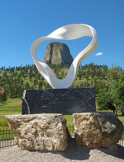 As you can likely visualize, this shape is meant to represent a puff of smoke from a sacred “peace pipe” common to American Indian tribes in the area including the Lakota Sioux. This ties into the legend of White Buffalo Calf Woman mentioned earlier, as she gave her people just such a sacred peace pipe shortly before leaving them and promising to returnat the end of days. The connection with modern Chief Arvol Looking Horse, discussed below, is that he is the 19th generation “Keeper of the Sacred Bundle of the Lakota Tribe” originally delivered by White Buffalo Calf Woman.Regarding the opening ceremony surrounding the dedication of this fine sculpture, the following quote is from-http://rapidcityjournal.com/news/local/top-stories/japanese-artist-to-place-sculpture-at-devils-tower/article_93899900-12ab-5921-ad4e-b50e32ab6c85.html As you can likely visualize, this shape is meant to represent a puff of smoke from a sacred “peace pipe” common to American Indian tribes in the area including the Lakota Sioux. This ties into the legend of White Buffalo Calf Woman mentioned earlier, as she gave her people just such a sacred peace pipe shortly before leaving them and promising to returnat the end of days. The connection with modern Chief Arvol Looking Horse, discussed below, is that he is the 19th generation “Keeper of the Sacred Bundle of the Lakota Tribe” originally delivered by White Buffalo Calf Woman.Regarding the opening ceremony surrounding the dedication of this fine sculpture, the following quote is from-http://rapidcityjournal.com/news/local/top-stories/japanese-artist-to-place-sculpture-at-devils-tower/article_93899900-12ab-5921-ad4e-b50e32ab6c85.html - Quote :
- The unveiling featured tribal drum groups, Japanese Taoko drummers, local and Japanese singers and tribal dancers. Despite cold, damp weather the ceremony was a spectacular event, having several cultures coming together as one. The unveiling began with Chief Arvol Looking Horse giving the blessing, followed by local singer Lorrie Redfield singing the National Anthem.
Chief Arvol Looking Horse had recently been honored by the United Nations, and for the unveiling ceremony presented information on “world peace and prayer day activities“. Interesting . . .Ms. Mako Miller, Honorary Consul General of Japan and resident of nearby Casper, Wyoming, said that the Circle of Sacred Smoke is “a significant showcase of unity” as it is “constructive” and “positive“. She went on to suggest that the very moment of the unveiling would “make history, connecting the United States with the rest of the world.“Devils Tower National Monument Superintendant Dorothy Firecloud went even further, saying that the sculpture alluded to “prayers connected to represent world peace.“Ms. Firecloud continued by stating (bold emphasis C.M.N.)- - Quote :
- The tower is the place where the White Buffalo Calf Woman brought the pipe and taught the Native American people how to live in a good way . . . how to do their prayers, the seven sacred rights . . . you know, the tower is a feminine entity and, based on that, it’s like the perfect spot for world peace to begin.
The sculpture itself is made of the finest carrara marble from Tuscany, Italy, and renowned sculptor Mr. Muto says it represents a “peace sculpture . . . a gesture of international good will“. With the esteemed Japanese artist himself bringing the statue over to join the two cultures together Ms. Firecloud said this is “like completing a circle.“It is certainly a compelling work of art, and the enthusiasm of the participants is encouraging, but please forgive me if I don’t believe that “world peace” is going to break out any moment now because of this gracious gesture by Mr. Muto. Rather, I see the spirit of antichrist at work in this spiritually-charged setting.For those interested in a quick “tour” of the Monument, see the nice video byroadtripstory who, by the way, call Devils Tower America’s Treasure. The narrator says the word “really” far too often but this is a concise, short video for your enjoyment;really-https://www.youtube.com/watch?v=XLYQcqOzCvYNo video can do this remarkable place justice, however, and I’d strongly encourage you to visit while there’s still time. After the Government slimdown ends, of course, as currently the Monument is closed to the public (that is to say, the taxpayers).Morehttp://nabiy4america.wordpress.com/ |
|