NATE :: HURRICANE :: WATCH OUT !!! ALERT !!!!*****UPDATED
Author
Message
Guest Guest
Subject: NATE :: HURRICANE :: WATCH OUT !!! ALERT !!!!*****UPDATED Fri Oct 06, 2017 9:54 am
[size=36]At least 22 people killed as Tropical Storm "Nate" hits Central America[/size]
Posted by TW on October 06, 2017 in categories Featured articles, Floods, Tropical Storms
As of early October 6, 2017, Tropical Storm "Nate" is blamed for the deaths of at least 22 people, 15 in Nicaragua and 7 in Costa Rica. However, there are 15 people still missing in Costa Rica and the death toll is expected to rise. The storm hit Nicaragua and Honduras on Thursday and is expected to hit or pass very near the Yucatan Peninsula before it enters warm waters and rapidly strengthens on its way toward US Gulf Coast. The storm made landfall in Nicaragua just a couple of hours after it officially reached tropical storm strength, but the country was already soaked by near-constant rain over the past 14 days, which left areas flooded and rivers swollen. Nicaragua's vice president Rosario Murillo said Thursday that at least 15 people have been killed. He didn't elaborate on many of the deaths but noted that three people who worked for the Health Ministry were swept away by a flooded canal in Juigalpa.
Costa Rican President Luis Guillermo Solis said seven people died in Costa Rica. At least 5 000 people in the country were evacuated into emergency shelters due to flooding. At least 15 people in Costa Rica remain missing.
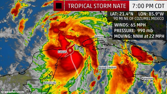
The death toll is expected to rise. As of 00:00 UTC on October 6, 2017, the center of Tropical Storm "Nate" was located 75 km (45 miles) W of Puerto Lempira, Honduras and 630 km (390 miles) SSE of Cozumel, Mexico. Its maximum sustained winds are 65 km/h (40 mph) and the system is moving NNW at 17 km/h (10 mph) with estimated minimum central pressure of 1 000 hPa. This general motion is expected to continue during the next couple of days with a significant increase in forward speed. On the latest forecast track, Nate will continue moving over eastern Honduras during the next couple of hours and exit into the northwestern Caribbean Sea. Its center is then expected to move near or over the northeastern tip of the Yucatan Peninsula and adjacent islands late Friday and move into the Gulf of Mexico on Saturday. Strengthening is likely once the center moves over the northwestern Caribbean Sea and Nate could be near hurricane strength as the center approaches the Yucatan Peninsula. This storm is expected to hit the US Gulf Coast late Saturday/early Sunday somewhere near the Louisiana-Mississippi border. Although this could still change, the impact will be widely felt throughout the region. As opposed to Harvey, Nate is not expected to stall over the coastline.
Tropical Storm "Nate" at 23:30 UTC on October 5, 2017. Credit: NOAA/GOES-16
A Tropical Storm Warning is in effect for:
Sandy Bay Sirpi Nicaragua to Punta Castilla, Honduras
Punta Herrero to Rio Lagartos, Mexico
A Tropical Storm Warning means that tropical storm conditions are expected somewhere within the warning area. A Hurricane Watch is in effect for:
Punta Herrero to Rio Lagartos, Mexico
A Hurricane Watch means that hurricane conditions are possible within the watch area. Interests elsewhere in Honduras, the Bay Islands, western Cuba, the Yucatan Peninsula, and the northern coast of the Gulf of Mexico should monitor the progress of Nate. A Hurricane Watch and a Storm Surge Watch will likely be required for portions of the northern Gulf Coast Thursday night or Friday morning (EDT). Nate is expected to produce the following rain accumulations into Saturday:
Southern Honduras and western Nicaragua: 152.4 to 254 mm (6 to 10 inches), max 508 mm (20 inches)
Eastern El Salvador and northern Costa Rica: 76.2 to 152.4 mm (3 to 6 inches), max 254 mm (10 inches)
Northern Honduras/Nicaragua, eastern Yucatan/Belize and western Cuba: 50.8 to 101.6 mm (2 to 4 inches), max 203.2 mm (8 inches)
Central Honduras: 50.8 to 101.6 mm (2 to 4 inches)
Cayman Islands and Jamaica: 25.4 mm to 50.8 mm (1 to 2 inches)
Heavy rainfall will occur over a wide area, including locations well away from the center along the Pacific coast of Central America. Rainfall across all of these areas may produce life-threatening flash floods and mudslides. A storm surge will raise water levels by as much as 30 to 90 cm (1 to 3 feet) above normal tide levels along the immediate coast in areas of onshore winds on the Yucatan Peninsula and the adjacent islands. Near the coast, the surge will be accompanied by large and destructive waves. Swells generated by Nate are affecting portions of the coast of Nicaragua and will begin to affect other land areas around the northwestern Caribbean during the next day or two. These swells are likely to cause life-threatening surf and rip current conditions. Featured image: Tropical Storm "Nate" damage in Costa Rica - October 5, 2017. Credit: Alerta Roja
Last edited by spring2 on Sat Oct 07, 2017 8:04 am; edited 1 time in total
Guest Guest
Subject: Re: NATE :: HURRICANE :: WATCH OUT !!! ALERT !!!!*****UPDATED Fri Oct 06, 2017 9:57 am
HAMMERING ALL SOUTHERN STATES! HOW MANY MORE? IS IT BEING MANIPULATED?
Guest Guest
Subject: Re: NATE :: HURRICANE :: WATCH OUT !!! ALERT !!!!*****UPDATED Fri Oct 06, 2017 9:59 am
The picture can be enlarged, open in new tab or ? https://www.nrlmry.navy.mil/tc-bin/tc_home2.cgi
https://www.nrlmry.navy.mil/TC.html
Guest Guest
Subject: Re: NATE :: HURRICANE :: WATCH OUT !!! ALERT !!!!*****UPDATED Fri Oct 06, 2017 10:06 am
IF YOU LIVE IN THE PATH, PLEASE PREPARE EARLY / NOW! LARGE CAPACITY WATER FILTER. SOLO STOVE OR SIMILAR? PREPACKAGED EMERGENCY FOOD IN BUCKET. OR --JUST LEAVE EARLY VACATION --!
[size=55]Tropical Storm Nate’s path takes it toward U.S.; warnings posted ahead of storm[/size]
POSTED 9:47 AM, OCTOBER 6, 2017, BY CNN WIRE, UPDATED AT 09:49AM, OCTOBER 6, 2017
FACEBOOK
TWITTER
TUMBLR
REDDIT
PINTEREST
EMAIL
Tropical Storm Nate killed 20 people in Nicaragua, Costa Rica and Honduras on Thursday, officials said. Hurricane and tropical storm warnings have been issued in three US states as the storm barrels northward. [The New York area could see the remnants of the storm, delivering heavy rain, by early Tuesday, though the forecast track could change.] Seven people are still missing after the storm hit Nicaragua, the country’s vice president said. It is forecast to make landfall on Mexico’s Yucatan Peninsula on Friday with up to 8 inches (20 centimeters) of rain. An advisory from the US National Hurricane Center said warnings had been issued for portions of the Louisiana, Mississippi and Alabama coastlines, with the storm expected to hit the region late Saturday or early Sunday as a Category 1 hurricane. Nate’s forecast track had shifted slightly by late Thursday morning, putting New Orleans — and its compromised drainage system — directly in the storm’s sights. The forecast cone also covered a small sliver of the Florida Panhandle, where officials still reeling from Hurricane Irma enacted emergency plans. Additionally, offshore oil and gas operators have evacuated personnel from six of the 737 manned oil and natural gas production platforms in the Gulf of Mexico, according to the Bureau of Safety and Environmental Enforcement. Unlike drilling rigs, which usually move locations, production platforms stay in the same location during a project. One drilling rig was moved out of the storm’s predicted path as a precaution. TRACK TROPICAL STORM NATE
Guest Guest
Subject: Re: NATE :: HURRICANE :: WATCH OUT !!! ALERT !!!!*****UPDATED Fri Oct 06, 2017 12:11 pm
[size=10]by Tyler Durden Oct 6, 2017 12:04 Pm[/size]
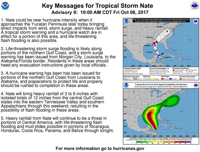
Confirming an earlier projection by Accuweather that showed Hurricane Nate will likely make landfall as a cateogry one storm somewhere between Louisiana and the Florida panhandle on Sunday, the NHC has issued a hurricane warning - the highest-priority of the agency's alert levels - for a broad swath of the Southern US stretching from Grand Isle Louisiana to the Florida-Alabama border.
[ltr] View image on Twitter [/ltr]
Quote :
Follow NHC Atlantic Ops
@NHC_Atlantic [ltr]Here are the key messages for Tropical Storm #Nate for Advisory 9. http://hurricanes.gov [/ltr]
8:14 AM - Oct 6, 2017
11 Reply
182182 Retweets
7373 likes
[ltr] Twitter Ads info and privacy[/ltr]
As we noted earlier, unlike with Hurricane Irma, most of the models for Hurricane Nate consistently see the storm moving directly north through the Gulf before turning to northeast to follow the eastern U.S. shorline. Here are more details about storm-related warnings from the NHC:
Quote :
SUMMARY OF WATCHES AND WARNINGS IN EFFECT: A Hurricane Warning is in effect for... * Grand Isle Louisiana to the Alabama/Florida border A Storm Surge Warning is in effect for... * Morgan City Louisiana to the Alabama/Florida border * Northern and western shores of Lake Pontchartrain A Tropical Storm Warning is in effect for... * Punta Herrero to Rio Lagartos Mexico * Pinar del Rio * Metropolitan New Orleans * Lake Pontchartrain and Lake Maurepas * West of Grand Isle to Morgan City Louisiana A Hurricane Watch is in effect for... * Punta Herrero to Rio Lagartos Mexico * Metropolitan New Orleans * Lake Pontchartrain and Lake Maurepas * East of the Alabama/Florida border to the Okaloosa/Walton County Line * West of Grand Isle to Morgan City Louisiana A Storm Surge Watch is in effect for... * East of the Alabama/Florida border to Indian Pass Florida A Tropical Storm Watch is in effect for... * East of the Okaloosa/Walton County Line to Indian Pass Florida * West of Morgan City to Intracoastal City Louisiana * Isle of Youth
Like they did with Hurricane Harvey, energy traders will be hyper focused this weekend on how the massive network of Gulf drilling platforms might be impacted by the storm. As Goldman Sachs explains, a new storm, Nate, is heading for the US Gulf Coast and is expected to land as a category 1 hurricane in Louisiana on Sunday. While the overall impact on the US oil sector is likely to be more modest than for Harvey (category 4 at landfall), it may have a similar supply impact given the path threatens more US Gulf Coast platforms. The demand impact is likely to be much smaller than Harvey given the lower intensity of the storm, the smaller amount of downstream capacity at risk and finally the smaller population impacted. On the refining side, 2.4 mb/d of refining capacity is at risk (13% of US capacity). We expect the storm to likely (1) have little or only a slightly bullish aggregate impact on the global oil market in October given the expected similarly modest supply and demand losses, (2) support US and global refining margins, with distillate likely to be most sustainably impacted given the already low inventory levels, and finally (3) reduce US crude export flows, initially weighing on the WTI-Brent spread. The resiliency of the US oil infrastructure during Harvey and the lesser intensity of the storm suggest however that these impacts should remain overall modest with flooding along the Mississippi River the likely greater threat. Of course, as Accuweather warned earlier, warm temperatures in the Gulf of Mexico could bolster the storm as it moves northeast from Central America toward the southwestern US.
researcher Admin
Posts : 14659 Reputation : 962 Join date : 2011-08-13 Age : 72 Location : San Diego
Subject: Re: NATE :: HURRICANE :: WATCH OUT !!! ALERT !!!!*****UPDATED Fri Oct 06, 2017 12:41 pm
Yeah, I've been following this one too. Looks like it is the real deal. New Orleans is declaring an emergency alert early. Guess they learned something from Katrina.
!! FOXTROT JULIETBRAVO !!
Guest Guest
Subject: UPDATE NATE!!! Sat Oct 07, 2017 8:03 am
INTENSIFYING!!!
https://www.youtube.com/watch?v=euI9YncMr5U
Guest Guest
Subject: 26 HRS TO IMPACT***!!! Tropical Storm Nate strengthens into a hurricane as Alabama, Florida, Louisiana and Mississippi all declare states of emergency Sat Oct 07, 2017 8:11 am
Tropical Storm Nate strengthens into a hurricane as Alabama, Florida, Louisiana and Mississippi all declare states of emergency in anticipation of landfall on Sunday
Tropical Storm Nate gained strength late Friday when it was officially upgraded to a hurricane
New Orleans mayor ordered an evacuation of some areas and mandatory curfew
Alabama, Florida, Louisiana and Mississippi declared states of emergency
So far, Nate has killed at least 22 people in Central America
By ASSOCIATED PRESS and DAILYMAIL.COM REPORTER PUBLISHED: 16:24 EDT, 6 October 2017 | UPDATED: 00:33 EDT, 7 October 2017
Tropical Storm Nate gained strength late Friday when it was officially upgraded to a hurricane which is headed straight for US Gulf Coast. States of emergency have been declared across parts of four states and New Orleans ordered some vulnerable residents to evacuate in anticipation of the hurricane's making landfall this weekend. The US Gulf Coast braced Friday for a fast-moving blast of wind, heavy rain and rising water. New Orleans Mayor Mitch Landrieu on Friday ordered an evacuation of some areas and a mandatory curfew ahead of Nate. The curfew will be in effect from Saturday evening to Sunday morning, the mayor said at a news conference. Alabama, Florida, Louisiana and Mississippi declared states of emergency as the storm twisted toward the US Gulf Coast on Friday after killing at least 22 people in Central America.
+16
On track: Tropical Storm Nate reached hurricane strength late Friday - prior to arriving on the shores of New Orleans on Sunday
+16
Power: This map shows Nate as it passed over the Yucatan Peninsula on the way into the Gulf of Mexico
+16
Torrential: The rain fall over the weekend and into next week shows that up to eight-inches is expected to fall over Mississippi and Alabama
+16
The map above shows current wave heights as of 8:00pm Eastern time on Friday
+16
The National Hurricane Center anticipates storm surge throughout much of the Gulf Coast, with Louisiana, Mississippi, and Alabama bearing the brunt of the hurricane
+16
Nate is likely to result in power outages across wide swaths of the southeastern United States
+16
Hurricane warnings are in effect in New Orleans, Biloxi, and Mobile. The storm is expected to do some damage as it moves inland
+16
Nate is currently generating considerable winds in surrounding areas, including Cuba and the Yucatan Peninsula of Mexico
Guest Guest
Subject: THEY SAY THEY MADE PROGRESS FIXING PUMP SYSTEM Sat Oct 07, 2017 8:48 am
ASK HOW MUCH AND WHY THEY WERE NOT ALL WORKING AFTER KATRINA?? THEY HAD TIME!!! WHAT LAME O" S https://www.prisonplanet.com/nate-aims-at-new-orleans-amid-worries-about-drainage-system.html Nate aims at New Orleans amid worries about drainage system
AP October 6, 2017 When Tropical Storm Nate formed Thursday and forecasts put New Orleans in its projected path, one big question loomed for residents and business owners: Will the pumps work? “That’s now a thought in everybody who lives in New Orleans,” said Devin Shearman, a manager at Katie’s restaurant and lounge, which flooded during an unexpected rainstorm Aug. 5. It was one of two flash floods this past summer that led to revelations about personnel and equipment problems at the New Orleans Sewerage and Water Board, the agency that runs the pumping system that drains the city. Some pumps weren’t working. Some turbines that provide power to the pumps were down. There weren’t enough people on hand to man the system. “Since early August, we have made substantial progress,” New Orleans Mayor Mitch Landrieu said of work to upgrade the city drainage system. But he warned at a Thursday news conference that extremely heavy rain and storm surge from Nate still could pose flood dangers. Read more
Guest Guest
Subject: Hurricane Nate slams Gulf Coast 11-feet of flooding Sun Oct 08, 2017 10:34 am
[size=38]Hurricane Nate makes second landfall slamming into the Gulf Coast leaving thousands without power and bringing up to 11-feet of flooding[/size]
Hurricane Nate made its second landfall near Biloxi, Mississippi on Saturday night after missing New Orelans
It brought at least 10 inches of rain to the region and may trigger flash flooding and storm surges of up to 9ft
The hurricane warning for New Orleans had been changed to a tropical storm warning
Mayor of New Orleans Mitch Landrieu lifted a curfew on Saturday night
Though it appears the city has been spared the worst, it could still face wind gusts as high as 55mph
The city erected flood gates on Saturday in anticipation of the storm as thundered through the Gulf of Mexico
Hurricane warnings and evacuation orders are in place along the Gulf Coast in anticipation of the storm
Evacuation shelters are being prepares in Mississippi and experts fear the storm may trigger tornadoes
Nate strengthened from a Tropical Storm to a Category 1 hurricane on Friday afternoon
Water from the Mississippi River may rise to 11ft as a result of the storm
By ARIEL ZILBER and JENNIFER SMITH FOR DAILYMAIL.COM and ASSOCIATED PRESS and REUTERS PUBLISHED: 08:04 EDT, 7 October 2017 | UPDATED: 02:03 EDT, 8 October 2017
Hurricane Nate made its second landfall near Biloxi late Saturday as a Category 1 storm with winds of 85 miles per hour, threatening parts of Louisiana, Mississippi and Alabama with torrential rain and flooding. The National Hurricane Center said the storm surge along the Mississippi coast could reach 11 feet, according to AL.com. On social media, people posted photos of flooding in Biloxi and other locations along the Gulf Coast. Widespread power outages were also reported throughout the coastal regions of Mississippi, Alabama, Louisiana, and the Florida panhandle.
The center of the storm will move across the Deep South, Tennessee Valley and central Appalachian Mountains through Monday. Earlier Saturday, Nate passed to the east of New Orleans, sparing the city its most ferocious winds and storm surge. And its quick speed lessened the likelihood of prolonged rain that would tax the city’s weakened drainage pump system. The city famous for all-night partying was placed under a curfew, effective at 7 p.m., but the mayor lifted it when it appeared the storm would pass by and cause little problems for the city. Still, the streets were not nearly as crowded as they typically are on a Saturday night and Mayor Mitch Landrieu asked people to shelter in place. +48
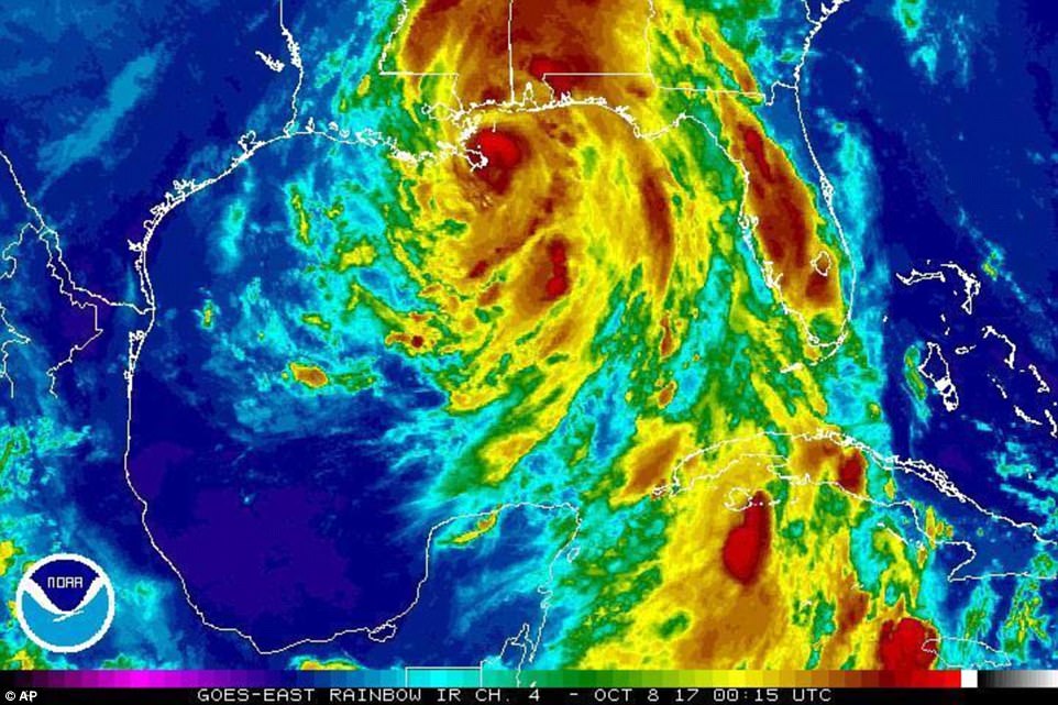
This satellite image obtained from the National Oceanic and Atmospheric Administration (NOAA) shows Hurricane Nate just moments before making landfall Saturday evening +48
This enhanced infrared satellite image made available by the National Oceanic and Atmospheric Administration shows Hurricane Nate approaching the mouth of the Mississippi River on Saturday


 [/ltr]
 NHC Atlantic Ops